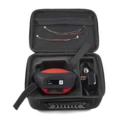
SparkFun RTK Facet
Sparkfun
 RSS
739.95 USD3006.27 PLN
- Sklep zagraniczny
- MPN:
- GPS-19984
- Producent:
- U-BLOX
- Waluta:
- dolar amerykański
- Dodany do bazy:
- Ostatnio widziany:
- Zmiana ceny:
- +6% (14.04.2025)
- Poprzednia cena:
- 699.95 USD
Sugerowane produkty dla sfrbx
Centimeter-Grade Surveying, Radically Simplified Designed and manufactured in Boulder, Colorado, USA, the SparkFun RTK Facet is your all-in-one solution for high-precision geolocation and surveying. It delivers centimeter-grade measurements in minutes, packing the power of a $10,000 surveying device into a package that is smaller, easier to use, and far more economical. For basic users, setup is incredibly simple. For advanced users, the RTK Facet is a flexible, powerful, and fully open-source tool. With full calibration by the National Geodetic Survey (NGS), you can trust its professional-grade accuracy for your most demanding projects. The Easiest RTK Workflow The RTK Facet is designed to work seamlessly with your smartphone. By connecting your phone to the RTK Facet over Bluetooth, your phone provides the correction data (from an NTRIP service via the internet) and simultaneously receives the high-accuracy NMEA position output. This powerful and simple workflow is compatible with common GIS software for Android and iOS, including SW Maps (Android / iOS), ArcGIS Survey123, Field Genius, SurvPC, Survey Master, Vespucci, QGIS, QField (Android / iOS), and any GIS application that supports NMEA over Bluetooth or TCP. Professional-Grade Hardware Included Under the hood, the RTK Facet integrates a powerful ESP32 WROOM, the industry-leading u-blox ZED-F9P GNSS module, a LiPo fuel gauge, and a microSD card slot for logging. Housed inside the protective dome is a surveyor-grade, multi-band L1/L2 antenna. This is the same antenna element found in our standalone high-performance antenna and features a precise Antenna Reference Point (ARP) for surveying:
* L1 ARP: 61.4mm from the base
* L2 ARP: 57.4mm from the base
Four Versatile Operating Modes The RTK Facet can be configured to fit any high-precision application:
* GNSS Positioning (Rover): Functions as a standalone, high-accuracy receiver. It calculates a position from the four GNSS constellations (GPS, GLONASS, Galileo, and BeiDou) with approximately 30cm (1ft) horizontal accuracy.
* GNSS Positioning with RTK (RTK Rover): This is the primary mode. When the Facet receives RTCM correction data (via Bluetooth/NTRIP or its radio port), it quickly obtains an RTK fix. This boosts accuracy to an incredible 14mm horizontal and 10mm vertical precision.
* GNSS Base Station: Mount the device on a fixed tripod or roof. The unit will perform a "survey-in" operation (60-120 seconds) to determine its own precise, fixed location. It then begins broadcasting RTCM correction data via its radio port for other rovers.
* GNSS Base Station (NTRIP Server): Functions as a base station that broadcasts its RTCM correction data over the internet via the built-in ESP32.
Fully Open Source and Customizable The RTK Facet is a fully open-source hardware product, programmed in Arduino. You have full access to the electrical and mechanical design files, allowing you to inspect, modify, and tailor the device to your exact needs. It is also capable of logging NMEA, RAWX, and SFRBX data directly to the microSD card for post-processing and research. Note: For a permanent base station, we recommend using our L1/L2 Surveying Antenna connected to a protected RTK Surveyor or a ZED-F9P breakout-based solution. See our DIY GNSS Reference Station tutorial for more details.
Elecena nie prowadzi sprzedaży elementów elektronicznych, ani w niej nie pośredniczy.
Produkt pochodzi z oferty sklepu Sparkfun